Help us tell the story of a time when Londoners routinely took to the river to get around their great city as part of our new community-based project: CRaFT (Causeways, Riverstairs and Ferry Terminals).
A CRaFT Guide to Surveying on the Foreshore
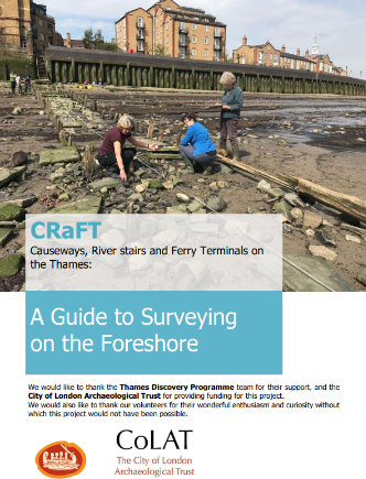
Our latest guide uses Horn Stars (Rotherhithe) to show how to compile a measured survey in the time-challenged environment of the foreshore, particularly if you’re new to the process.
> View the guide
We would like to thank the Thames Discovery Programme team for their support in producing this guide, and the City of London Archaeological Trust for providing funding. Thank you also to our volunteers for their enthusiasm and curiosity that made this guide possible.![]()
![]()
Video CRaFT quick guide:
How to lay a baseline on the foreshore.
Thames Discovery Programme showed our volunteers at Horn Stairs how to lay a baseline on the foreshore to draw the causeway.
About Horn Stairs
This is an old landing place for wherries, jutting out from the Rotherhithe bank and also known as Cuckold’s Point. Although the presence of stairs is not shown on early maps, the landing place at Cuckold’s Point is referenced in Samuel Pepys’ diary (20 February 1662) and is also
represented on a painting by Samuel Scott (c. 1750-1760). This long history as a landing place means there are multiple phases of causeway present on the foreshore.
What is CRaFT?
In the centuries before cars, taxis, buses and trains there were hundreds of CRaFT (causeways, riverstairs and ferry terminals) where passengers could board a boat at a time when Londoners routinely used the Thames to get about. Some CRaFT were private but others were ‘public transport’ landing places, like today’s bus stops, taxi ranks or tube stations.
This exciting project aims to uncover, discover, or rediscover, the histories of the Thames landing places from Vauxhall to Greenwich. Through documentary research, cartography, and of course through past, present and future foreshore fieldwork, the project will tell the stories of the people who used the landing places, as well as those who relied on them for their livelihood.
Many CRaFT have been lost to redevelopment or have disappeared as part of the social and economic change brought about by bridges and new modes of transport. Others still exist, either inland, like York gate on the Victoria Embankment, or on the foreshore, for example at Trig Lane or Custom House in the City of London – although they are no longer used as landing places.
Get involved
If you would like to join CRaFT, email us at colas_outreach@yahoo.co.uk > Follow us on X (formerly known as Twitter)
There are so many ways to get involved, such as ‘digging’ through archives, foreshore fieldwork, discovering CRaFT in paintings or literature, blogging, foreshore photography, and more!
Many CRaFT have disappeared, however there is a wealth of historic information available to tell their story. On the foreshore, volunteers record the remaining CRaFT. The Thames is continually eroding the foreshore – revealing or destroying features – and volunteers help keep track of changes to CRaFT over time.
